Translate Language
What Exactly is Null Island? How Does This Relate to GIS and Technology?
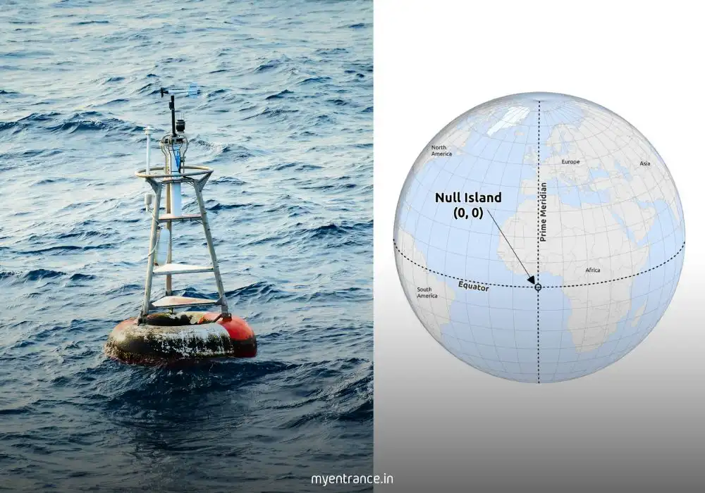
In the vast world of data and maps, errors need a place to go. That place is Null Island, a fictional point at coordinates 0°N, 0°E. While it doesn’t exist on any real map, it plays a very real role in catching data errors and even aiding climate science, making it a fascinating topic for curious minds.
Have you ever entered an address online and seen the map pin drop in the middle of the ocean? That misplaced data likely ended up at a very special, albeit entirely fictional, location: Null Island.
What Exactly is Null Island?
Null Island is the nickname for the coordinates 0° latitude (the equator) and 0° longitude (the prime meridian), a spot in the Atlantic Ocean off the coast of West Africa. It’s not a real landmass. Instead, it’s a clever inside joke among cartographers and a critical tool for data scientists.
Its purpose is to act as a digital dumping ground. When mapping software (a process called geocoding) can’t understand an address—due to a typo, missing information, or corrupted data—it often defaults to these (0,0) coordinates. Think of it as an “island of misfit data,” catching everything from misspelled city names to non-existent postal codes.
Why is There a Buoy at a Place That Doesn’t Exist?
Here’s where the story gets interesting for science enthusiasts. Even though the island is a myth, the location is very real and scientifically significant. Anchored precisely at 0,0 is a NOAA weather buoy known as Station 13010 – Soul.
This buoy is part of a major international project (PIRATA) that monitors crucial climate data like:
Sea surface temperature
Air temperature and humidity
Wind speed and direction
This information is fed into global weather models and is vital for climate research and predicting phenomena like hurricanes and El Niño. So, a point known for errors also serves as a cornerstone of real-world scientific observation.
Test your knowledge with our Daily News Quiz & Key Pointers.
How Does This Relate to GIS and Technology?
The “why” behind the error is rooted in the global coordinate system (WGS84) that powers all modern GPS and digital maps. The coordinates (0,0) are a mathematical default. When a system fails, it retreats to this baseline, creating a massive, easily identifiable cluster of errors that data analysts can quickly find and correct.
Questions and Answers for Your Exam Preparation
What are the coordinates of Null Island?
Answer: 0 degrees latitude and 0 degrees longitude.
Null Island is located at the intersection of which two major lines?
Answer: The Equator (0° latitude) and the Prime Meridian (0° longitude).
What is the primary purpose of Null Island in Geographic Information Systems (GIS)?
Answer: To act as a placeholder and easily identifiable point for catching and flagging geocoding errors and misplaced data.
What real-world scientific object is located at the coordinates of Null Island?
Answer: A NOAA weather observation buoy (Station 13010 – Soul) that is part of the PIRATA project for monitoring tropical Atlantic climate data.
The concept of Null Island best illustrates the importance of what in data management?
Answer: Data validation and accuracy. It highlights how errors can be systematically identified and managed.
Students often struggle with last-day stress; our Quick Revision Strategies will help you stay calm and focused.
Why is This Important for Exams like UPSC, SSC, and Kerala PSC?
Understanding concepts like Null Island is not about memorizing a trivial fact. It’s about demonstrating a multidisciplinary grasp of modern issues, which is key to scoring high marks.
Science & Technology: It directly relates to syllabus topics like GIS technology, data accuracy, and the importance of scientific observation systems like the PIRATA project.
Geography: It reinforces your understanding of global coordinates, the equator, the prime meridian, and their significance.
Current Affairs & Environment: Climate monitoring is a hot topic. Knowing how data is collected for weather prediction shows you’re aware of contemporary scientific efforts.
Critical Thinking: Questions about such unique topics test your ability to link different fields—technology, geography, and environmental science—a skill highly valued in competitive exams.
So, the next time you see a question on data, maps, or climate tech, remember the story of the island that never was. It might just be the key to unlocking a higher score.
Read More Topics