1. Introduction: The Great Sahyadri
The Western Ghats, also known as the Sahyadri Mountains, constitute one of the most significant geographical features of the Indian subcontinent. Extending approximately 1,600 km along the western edge of India, this mountain range is not just a collection of hills but a biological treasure trove and a critical regulator of the Indian monsoon. For a UPSC aspirant, understanding the Western Ghats requires a multi-dimensional approach covering physical geography, environmental ecology, and administrative policy frameworks.
Recognized as one of the world’s eight ‘hottest hotspots’ of biological diversity, the Western Ghats were inscribed into the UNESCO World Heritage list in 2012. They are older than the Himalayan mountains and represent geomorphic features of immense global importance. The range traverses through six states: Gujarat, Maharashtra, Goa, Karnataka, Kerala, and Tamil Nadu.
💡 Click to Reveal: Why are they called ‘Ghats’?
The term ‘Ghat’ originates from the Sanskrit word ‘ghatta’, meaning a flight of steps leading down to a river. In the context of the Western Ghats, it refers to the stepped appearance of the mountains when viewed from the coast, caused by the volcanic basaltic trap formations.
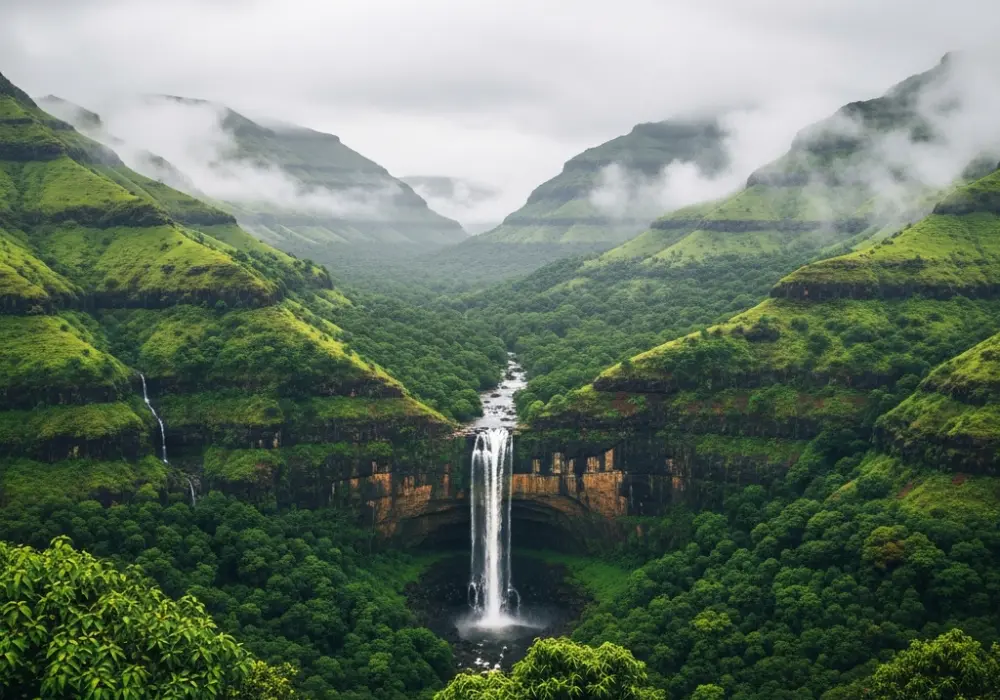
2. Physical Geography & Physiography
The Western Ghats are a continuous chain of mountains, unlike the Eastern Ghats which are highly dissected. They run parallel to the western coast, starting from the south of the Tapti river and ending at Kanyakumari. The average elevation is about 1,200 meters, with several peaks exceeding 2,000 meters.
Key Features:
- The Northern Section: From Tapti to Goa. This region is characterized by basaltic (Deccan Trap) formations. The peaks are lower compared to the southern section. Kalsubai is the highest peak in Maharashtra.
- The Central Section: From Goa to the Nilgiri Mountains. This area transitions from basalt to granitic and gneissic rocks. It features dense evergreen forests and is the source of many rivers like the Sharavathi.
- The Southern Section: Separated from the main range by the Palghat Gap. This section includes the Anaimalai Hills, Cardamom Hills, and Palani Hills. Anamudi (2,695m) in Kerala is the highest peak of the Western Ghats and South India.
The Western Ghats act as a major watershed for peninsular India. They give rise to prominent perennial rivers such as the Godavari, Krishna, and Kaveri, which flow eastward into the Bay of Bengal, and shorter, swifter westward-flowing rivers like the Periyar and Netravati.
3. Geological Origins: The Escarpment Theory
From a geological perspective, the Western Ghats are not ‘true’ mountains formed by folding (like the Himalayas). Instead, they are the faulted edge of the Deccan Plateau. During the breakup of Gondwanaland approximately 150 million years ago, the Indian plate moved northward. The western edge of the plate subsided into the Arabian Sea due to tectonic forces and the impact of the Reunion Hotspot.
The result is a massive escarpment: a steep, cliff-like slope facing the west and a gentle slope dipping toward the east. This structural asymmetry explains why almost all major peninsular rivers originate near the western coast but flow towards the east coast.
💡 Click to Reveal: The Reunion Hotspot Connection
As the Indian plate passed over the Reunion Hotspot, massive volcanic eruptions occurred, creating the Deccan Traps. The weight of these basaltic flows caused the crust to sag and crack, facilitating the formation of the Western Ghats’ steep western face.
4. Climatic Significance: The Monsoon Barrier
The Western Ghats play a decisive role in the Indian climate. They act as a massive barrier to the moisture-laden South-West Monsoon winds coming from the Arabian Sea. This results in Orographic Rainfall.
The windward side (western slopes) receives extremely heavy rainfall (often exceeding 250 cm), sustaining tropical evergreen forests. In contrast, the leeward side (eastern side) falls in the rain shadow region, receiving significantly lower rainfall, leading to semi-arid conditions in parts of Maharashtra and Karnataka.
Furthermore, the Western Ghats moderate the temperature of the Deccan plateau. The high-altitude regions, such as Munnar, Ooty, and Mahabaleshwar, maintain a cool temperate climate throughout the year, distinct from the surrounding tropical plains.
5. Biodiversity and Endemism
The Western Ghats represent a global biodiversity hotspot. The high rainfall and complex topography have resulted in a variety of vegetation types, ranging from scrub jungles to montane grasslands (Sholas) and tropical rainforests.
Endemic Species (UPSC Favorites):
- Lion-tailed Macaque: An endangered primate found only in the rainforests of the Western Ghats.
- Nilgiri Tahr: The state animal of Tamil Nadu, primarily found in the Eravikulam National Park.
- Malabar Large-spotted Civet: One of the world’s rarest mammals.
- Purple Frog: A unique burrowing frog discovered recently that surfaces only for a few days a year.
The region is also the ‘Global Center of Origin’ for many spices, most notably Black Pepper and Cardamom. The Shola-Grassland ecosystem in the high altitudes of the Nilgiris and Anaimalais is a unique ecological feature where stunted evergreen trees grow in valleys surrounded by vast grasslands.
6. Environmental Governance: Gadgil vs. Kasturirangan
For the UPSC Mains exam, the debate between development and conservation in the Western Ghats is a critical theme. Two major committees were formed to recommend measures for protecting this fragile ecosystem:
1. Madhav Gadgil Committee (WGEEP – 2011)
The Western Ghats Ecology Expert Panel (WGEEP) recommended that the entire Western Ghats be designated as an Ecologically Sensitive Area (ESA). It proposed three levels of sensitivity (ESZ 1, 2, and 3) and recommended a near-total ban on mining and large dams in ESZ 1. It was criticized for being too ‘environmentally radical’ and difficult to implement.
2. Kasturirangan Committee (HLWG – 2013)
To provide a more ‘balanced’ approach, the High-Level Working Group recommended that only about 37% of the total area (approx. 60,000 sq km) be declared as ESA. It proposed a ban on ‘red category’ industries, mining, and quarrying in these areas but allowed for more developmental flexibility than the Gadgil report.
Recent Context: The recurring landslides in Wayanad (2024) and the devastating Kerala floods (2018) have reignited the demand for the implementation of Gadgil-style conservation measures to prevent ecological disasters caused by unscientific land-use changes.
UPSC Interactive Mock Quiz
Q1. Consider the following statements regarding the Western Ghats:
1. They are continuous and can be crossed through passes only.
2. They are higher in elevation than the Eastern Ghats.
3. Their height increases from South to North.
Which of the statements given above is/are correct?
- A) 1 and 2 only
- B) 2 and 3 only
- C) 1 and 3 only
- D) 1, 2, and 3
✅ Click to Reveal Answer & Deep Explanation
Correct Answer: A
Statements 1 and 2 are correct. The Western Ghats are continuous, unlike the Eastern Ghats which are dissected by rivers. They have a higher average elevation (900-1600m) than the Eastern Ghats (600m). Statement 3 is incorrect because the height of the Western Ghats actually increases from North to South. Anamudi, the highest peak, is located in the southern part (Kerala).
Q2. Which of the following mountain passes connects Mumbai to Pune?
- A) Thal Ghat
- B) Bhor Ghat
- C) Pal Ghat
- D) Senkotta Gap
✅ Click to Reveal Answer & Deep Explanation
Correct Answer: B
Bhor Ghat connects Mumbai and Pune. Thal Ghat (also known as Kasara Ghat) connects Mumbai to Nashik. Pal Ghat is a major break in the Western Ghats between the Nilgiri Hills to the north and Anaimalai Hills to the south, connecting Kerala (Palakkad) to Tamil Nadu (Coimbatore).
Q3. With reference to the ‘Shola’ forests of the Western Ghats, consider the following:
1. They are tropical montane wetlands.
2. They consist of stunted evergreen trees separated by grasslands.
3. They are found only in the northern section of the Western Ghats.
Which of the statements given above is/are correct?
- A) 1 only
- B) 2 only
- C) 1 and 2 only
- D) 2 and 3 only
✅ Click to Reveal Answer & Deep Explanation
Correct Answer: B
Statement 2 is the classic definition of Sholas. Statement 1 is incorrect because they are montane forests, not primarily wetlands (though they have water-retaining properties). Statement 3 is incorrect because Sholas are characteristic of the Southern Western Ghats (Nilgiris, Anaimalais, and Palani hills) above 1500 meters elevation, not the northern section.
Q4. The ‘Gadgil Committee Report’ and ‘Kasturirangan Committee Report’, sometimes seen in the news, are related to:
- A) Constitutional reforms in India
- B) Ganga River Rejuvenation
- C) Protection of Western Ghats
- D) National Education Policy
✅ Click to Reveal Answer & Deep Explanation
Correct Answer: C
Both committees were constituted by the Ministry of Environment and Forests (MoEF) to study and recommend conservation measures for the Western Ghats. The Gadgil report was seen as more conservation-oriented, while the Kasturirangan report attempted to balance conservation with economic development.
Q5. Which of the following rivers do NOT originate in the Western Ghats?
- A) Godavari
- B) Krishna
- C) Kaveri
- D) Mahanadi
✅ Click to Reveal Answer & Deep Explanation
Correct Answer: D
The Mahanadi originates in the highlands of Chhattisgarh (Sihawa in Dhamtari district), which is part of the Eastern Ghats/Central Indian highlands complex. Godavari (Trimbakeshwar), Krishna (Mahabaleshwar), and Kaveri (Talakaveri) all originate in the Western Ghats.
Ready to Ace your UPSC Preparation?
Get personalized guidance, updated study materials, and daily answer writing practice.
💬 Chat with our Experts on WhatsApp (+91 9526806124)