Mastering the UPSC Mains General Studies Paper 1 requires a deep and integrated understanding of India’s complex social fabric and its dynamic physical geography. This expert guide provides a strategic framework for decoding two frequently tested and critical topics: the challenges faced by Particularly Vulnerable Tribal Groups (PVTGs) and the geophysical phenomenon of earthquakes. A thorough grasp of these areas is non-negotiable for any serious civil services aspirant aiming for a top-tier rank.
The Human Element: Understanding Particularly Vulnerable Tribal Groups (PVTGs)
Within the broader category of Scheduled Tribes, the Particularly Vulnerable Tribal Groups represent the most marginalized and disadvantaged sections of our society. First identified by the Dhebar Commission in 1973, these communities exhibit specific characteristics such as a pre-agricultural level of technology, extremely low levels of literacy, and a stagnant or diminishing population. Their isolation, often in remote and inaccessible terrains, compounds their vulnerabilities, leading to significant challenges in healthcare, nutrition, and livelihood. Government interventions and constitutional safeguards exist, but their effective implementation is often hampered by geographical barriers and a lack of community-specific data. For a Mains answer, it is crucial to move beyond mere definitions and analyze the socio-economic and cultural factors that perpetuate their vulnerability, including habitat loss, erosion of traditional knowledge, and the complexities of assimilation versus preservation.
The Physical Realm: Decoding India’s Seismic Vulnerability
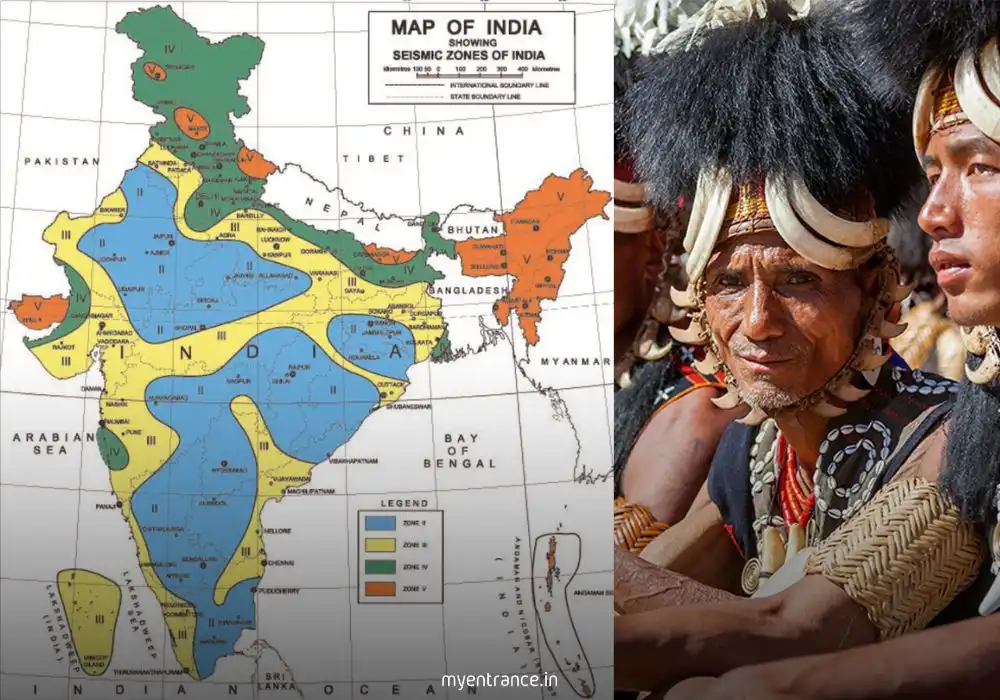
India’s unique geological position, marked by the continuous collision of the Indian and Eurasian tectonic plates, makes it one of the world’s most seismically active regions. This is a core topic under the “geophysical phenomena” section of the GS-1 syllabus. The Bureau of Indian Standards has classified the country into four distinct seismic zones, from Zone II (low intensity) to Zone V (very high intensity). The entire Himalayan belt, the northeastern states, and parts of Gujarat fall under the high-risk Zone V, making them highly susceptible to devastating earthquakes. A comprehensive understanding requires knowledge of the underlying tectonic processes, the characteristics of each seismic zone, and the potential impact of seismic events on India’s population, infrastructure, and developmental projects. Answering questions on this topic requires a scientific temperament combined with an awareness of the administrative and disaster management challenges involved. Explore all exam updates, quizzes, and study materials on Myentrance – Your Complete Exam Preparation Portal.
Why is this a Crucial Topic for Your Mains Exam?
UPSC consistently tests these topics to evaluate a candidate’s holistic understanding of India. Questions on PVTGs are not just about social issues; they are a test of your grasp on governance, social justice, constitutional provisions, and the ethics of development. They reveal your sensitivity as a future administrator towards the most vulnerable populations. Similarly, questions on earthquakes assess your foundational knowledge of physical geography, but more importantly, your ability to link this knowledge to practical applications in disaster management, urban planning, and infrastructure policy, which are central themes in GS Paper 3. Mastering these subjects demonstrates the interdisciplinary analytical skill that the Civil Services examination demands. Build a strong foundation with our Comprehensive Static GK Guide that covers important topics for all exams.
Sample Mains Questions and Expert-Crafted Answers
Question 1: Despite various government schemes, Particularly Vulnerable Tribal Groups (PVTGs) continue to face existential threats. Critically analyze the primary challenges hindering their holistic development.
Answer:
The challenges impeding the holistic development of PVTGs are multifaceted, stemming from historical neglect and systemic inefficiencies. The primary obstacle is geographical and social isolation, which creates a last-mile delivery problem for welfare schemes, leading to poor access to healthcare, education, and nutrition. This is compounded by a loss of traditional livelihoods due to forest degradation and restrictive conservation laws, without the provision of viable alternatives. Furthermore, a lack of reliable, community-specific data makes policy formulation a top-down exercise, often failing to address their unique cultural and social needs. Issues like debt bondage, land alienation, and severe health problems like sickle-cell anemia and malnutrition persist. Therefore, overcoming these challenges requires a micro-targeted, culturally sensitive approach rather than a one-size-fits-all policy.
Question 2: Explain the tectonic reasons for the high seismic vulnerability of the Himalayan region. How does this vulnerability impact development projects in the area?
Answer:
The Himalayan region’s high seismic vulnerability is a direct consequence of its geology as a young, active fold mountain range. It is located at the convergent boundary where the Indian Plate is subducting beneath the Eurasian Plate at a rate of approximately 40-50 mm per year. This immense tectonic stress accumulates in the crust and is periodically released in the form of earthquakes along major fault lines like the Main Central Thrust (MCT) and the Main Boundary Thrust (MBT). This inherent instability poses significant risks to developmental projects. It necessitates stringent building codes for infrastructure like dams, tunnels, and roads, increasing construction costs and complexity. The risk of earthquake-induced landslides further jeopardizes these projects and local habitations, demanding sophisticated geological surveys and risk-mitigation strategies to ensure sustainable and safe development.
Question 3: Suggest a multi-pronged strategy for the socio-economic empowerment of PVTGs while ensuring the preservation of their unique cultural identity.
Answer:
A multi-pronged strategy for PVTG empowerment must be rooted in the principle of “conservation-cum-development.” The first prong is securing their habitat and livelihood by recognizing community forest rights and promoting non-timber forest produce (NTFP) value chains. The second involves providing culturally appropriate and mobile healthcare and education services, using local dialects and respecting their traditional knowledge systems. The third prong is economic empowerment through skill development in traditional crafts and linking them to niche markets, ensuring they receive fair value. Finally, a crucial component is participatory planning, where PVTG communities, especially their youth and women, are active partners in designing and implementing development schemes like the recently launched PM-JANMAN mission, ensuring their cultural identity is not eroded but celebrated as a part of their growth.
Question 4: India’s seismic zonation map highlights significant risks across the country. Discuss the key components of a robust earthquake preparedness and mitigation strategy for high-risk urban centers.
Answer:
A robust earthquake preparedness strategy for high-risk urban centers must be proactive, not reactive. The first key component is strict enforcement of the National Building Code, especially for critical infrastructure like hospitals, schools, and public buildings, alongside retrofitting of older structures. The second component is the development of a comprehensive early warning and public communication system to disseminate information effectively before and during a disaster. The third component involves capacity building, which includes training specialized search-and-rescue teams like the NDRF, conducting regular mock drills for citizens, and preparing community-level disaster management plans. Finally, micro-zonation of cities to identify specific areas of higher risk and creating resilient lifeline infrastructure (water, power, communication) are vital for minimizing damage and ensuring a swift response.
Question 5: How can modern geographical tools like GIS and remote sensing be leveraged for both the welfare of PVTGs and for earthquake risk assessment in vulnerable zones?
Answer:
Geographic Information Systems (GIS) and remote sensing are powerful tools with dual applications in these contexts. For PVTG welfare, these technologies can be used to map their remote habitats, track forest resource depletion, and plan the delivery of essential services like mobile health units or water sources with precision. This data-driven approach helps in monitoring the impact of development schemes and ensuring resources reach the intended beneficiaries. For earthquake risk assessment, remote sensing can identify active fault lines and monitor land use changes in vulnerable zones, while GIS can be used to create detailed risk maps by overlaying data on population density, building types, and critical infrastructure. This allows authorities to simulate earthquake scenarios, plan effective evacuation routes, and prioritize areas for mitigation efforts, thereby enhancing overall resilience for both human and physical geography challenges.