Welcome to myentrance.in, your ultimate guide to mastering competitive exams. In today’s dynamic world, staying updated with significant national advancements is not just about general awareness; it’s a crucial component of your success in exams like UPSC, SSC, PSC, and other government recruitment tests. Let’s delve into a remarkable stride India has made in disaster preparedness, a topic that perfectly blends current affairs, science and technology, and general knowledge.
India’s Self-Reliance in Disaster Preparedness: A Game Changer
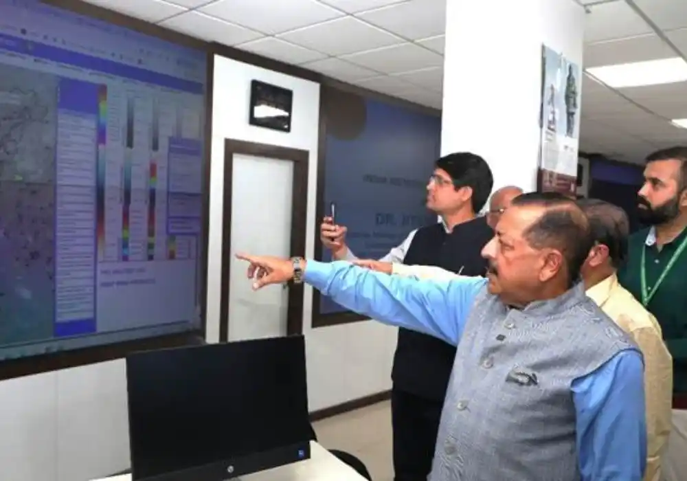
India is increasingly focusing on indigenous solutions to complex challenges, and disaster management is no exception. Recently, the India Meteorological Department (IMD) achieved a significant milestone by developing an in-house, cutting-edge Web-GIS-based Multi-Hazard Early Warning Decision Support System (DSS). This isn’t just a technical achievement; it represents a major step towards national self-reliance and has garnered high praise from Science and Technology Minister Dr. Jitendra Singh. He highlighted the system’s ability to save a colossal sum of nearly 250 crore rupees, effectively ending India’s dependence on foreign vendors for such critical technology. For aspirants, this news isn’t just a headline; it’s a testament to India’s growing scientific capabilities and a potential source of direct questions in your upcoming government exams.
Unpacking the Technology: What is the Web-GIS DSS?
So, what exactly is this groundbreaking system? The Web-GIS-based Multi-Hazard Early Warning Decision Support System is a sophisticated digital platform designed to provide timely and accurate alerts for various natural disasters.
* What it is: It’s an advanced, web-enabled geographical information system (GIS) that integrates data from multiple sources to predict and monitor a range of natural hazards.
* How it works: By leveraging Geographical Information Systems, the DSS creates interactive maps and visual representations of potential disaster zones, allowing authorities to analyze risks and make informed decisions swiftly. It processes vast amounts of meteorological, hydrological, and other environmental data to forecast events like floods, cyclones, heatwaves, and more, well in advance.
* Why it’s crucial: Early warnings are paramount in minimizing loss of life and property during natural calamities. This system empowers disaster management agencies with critical information, enabling them to mobilize resources, issue advisories, and plan evacuation strategies effectively and efficiently. This indigenous development also means India controls the technology end-to-end, enhancing national security and data integrity.
Why This Matters for Your Competitive Exams
For students preparing for UPSC, SSC CGL, PSC, and other government entrance exams, understanding the implications of such developments is key.
* Current Affairs: This is a direct current affairs topic, highlighting a significant government initiative under the Ministry of Earth Sciences. Expect questions on the IMD, Dr. Jitendra Singh, and the specific name/function of the DSS.
* General Knowledge (GK): It’s an excellent example of applied science and technology in India. Questions could cover topics like GIS technology, disaster management frameworks in India, or the role of the IMD.
* Essays and Descriptive Papers: For exams with descriptive sections, this topic provides rich material for essays on “Self-Reliance in Technology,” “India’s Disaster Preparedness,” or “The Role of Science in National Development.” You can discuss the economic benefits, strategic independence, and humanitarian impact.
* Interview Preparation: Being knowledgeable about such national achievements demonstrates your awareness and analytical skills, which are highly valued in interviews for civil services and other top-tier government roles.
By familiarizing yourself with not just the news, but the ‘why’ and ‘how’ behind it, you transform information into valuable knowledge that directly aids your exam preparation. Myentrance.in provides you with similar in-depth analyses, interactive quizzes, and comprehensive study materials to ensure you’re always a step ahead.
Frequently Asked Questions (FAQs)
Q1: What is the primary purpose of the IMD’s Web-GIS-based Multi-Hazard Early Warning Decision Support System (DSS)?
A1: The primary purpose of the IMD’s Web-GIS DSS is to provide timely and accurate early warnings for multiple natural hazards, such as floods, cyclones, and heatwaves. This enables disaster management agencies to make informed decisions quickly, minimizing loss of life and property across India.
Q2: Which government minister praised this new system and why is it considered significant for India?
A2: Science and Technology Minister Dr. Jitendra Singh praised the system. It is considered significant because it is an indigenous development, saving India nearly 250 crore rupees by ending dependence on foreign vendors, thereby bolstering national self-reliance in critical technological infrastructure for disaster management.
Q3: How does the Web-GIS DSS contribute to India’s “Atmanirbhar Bharat” (Self-Reliant India) initiative?
A3: The Web-GIS DSS contributes significantly to the “Atmanirbhar Bharat” initiative by being developed entirely in-house by the IMD. This demonstrates India’s capability to build advanced technological solutions for national challenges without external reliance, promoting technological sovereignty and economic independence.
Q4: For competitive exam aspirants, which subjects or topics would this information be most relevant to?
A4: For competitive exam aspirants, this information is highly relevant to Current Affairs, General Knowledge (GK), Science and Technology, Environment and Disaster Management, and potentially for essay topics in descriptive papers for exams like UPSC, SSC, and various PSCs.
Q5: Who developed the Web-GIS-based Multi-Hazard Early Warning Decision Support System?
A5: The Web-GIS-based Multi-Hazard Early Warning Decision Support System was developed in-house by the India Meteorological Department (IMD).