Select Medium
CLASS X SOCIAL SCIENCE 2 CHAPTER 7
India : The Land of Diversities
LESSON OVERVIEW
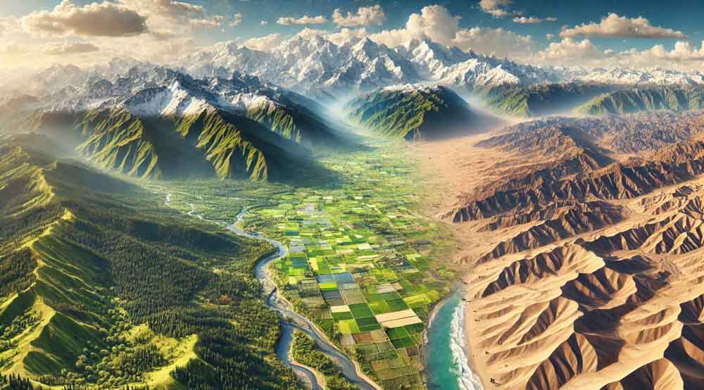
India’s diverse topography is a remarkable tapestry of landscapes, ranging from the towering snow-capped peaks of the Himalayas to the arid expanses of the Thar Desert. The country’s geography also includes lush green valleys, dense forests of the Western Ghats, and the fertile plains of the Ganges. This rich variety of terrains contributes significantly to India’s unique climate, biodiversity, and cultural heritage.
1. The Northern Mountains
The Northern Mountains of India are a crucial part of the country’s geography, forming a natural barrier along the northern border. This vast mountain system includes the Himalayas, the Karakoram Range, and the Trans-Himalayas. The Himalayas, known as the “Abode of Snow,” are the most prominent, stretching across five Indian states: Jammu & Kashmir, Himachal Pradesh, Uttarakhand, Sikkim, and Arunachal Pradesh. These ranges are home to some of the highest peaks in the world, including Mount Everest and Kanchenjunga. The Northern Mountains play a vital role in influencing India’s climate, acting as a barrier to cold winds from Central Asia and capturing the monsoon rains, which are crucial for agriculture. These mountains are also the source of several major rivers, such as the Ganges, Yamuna, and Brahmaputra, which sustain the fertile plains of northern India.
Tip: Remember the acronym “HKT” – Himalayas, Karakoram, and Trans-Himalayas – to recall the major ranges in the Northern Mountains.
2. Trans Himalayas
The Trans-Himalayas, also known as the Tibetan Himalayas, are located north of the main Himalayan range. This region includes the Karakoram, Ladakh, Zanskar, and Kailash ranges. The Trans-Himalayas are characterized by their high-altitude plateaus, arid climate, and sparse vegetation. These ranges are geologically younger than the main Himalayas and contain significant mineral resources, including copper, gold, and uranium. The region is sparsely populated, with Ladakh being one of the few inhabited areas. The Trans-Himalayas also house some important glaciers, such as the Siachen Glacier, which is the longest in the Karakoram Range.
Tip: Use “TLC” – Trans-Himalayas, Ladakh, and Copper – to remember the region’s key features.
3. Himalayas and the Eastern Highlands
The Himalayas are not only a physical barrier but also a cultural and spiritual symbol in India. The range is divided into three main parts: the Himadri (Great Himalayas), Himachal (Lesser Himalayas), and Siwaliks (Outer Himalayas). The Eastern Highlands, which include the Purvanchal Range and the Meghalaya Plateau, are an extension of the Himalayas in the northeastern region of India. The Eastern Highlands are known for their rich biodiversity, heavy rainfall, and unique topography, which includes rolling hills and deep valleys.
Tip: Remember “HHS” – Himadri, Himachal, Siwaliks – to recall the divisions of the Himalayas.
4. Mount Everest
Mount Everest, standing at 8,848 meters, is the highest peak in the world. Located in the Mahalangur range of the Himalayas on the border between Nepal and the Tibet Autonomous Region of China, it has been a symbol of human endurance and aspiration. The first successful ascent was made by Sir Edmund Hillary and Tenzing Norgay in 1953. Mount Everest is not just a geographical marvel but also a vital part of the local culture and economy, attracting thousands of climbers and trekkers every year. However, the increase in tourism has also led to environmental concerns, including pollution and the melting of glaciers.
Tip: Use “EHA” – Everest, Highest, Adventure – to remember the key points about Mount Everest.
5. Himadri
Himadri, also known as the Great Himalayas, is the innermost and highest range of the Himalayan mountains. It consists of some of the tallest peaks in the world, including Mount Everest, Kanchenjunga, and Nanda Devi. The Himadri range is characterized by permanent snow cover and glaciers, making it the source of many major rivers like the Ganges, Yamuna, and Brahmaputra. The harsh climatic conditions make the region largely uninhabitable, but it remains a crucial part of India’s geography, especially for its water resources.
Tip: Remember “HGP” – Himadri, Glaciers, Peaks – to recall the features of the Himadri range.
6. Himachal
The Himachal, or Lesser Himalayas, is the middle range of the Himalayas, lying between the Himadri in the north and the Siwaliks in the south. The Himachal range includes well-known hill stations like Shimla, Mussoorie, and Darjeeling, which are popular tourist destinations. This range is characterized by dense forests, fertile valleys, and moderate heights, with peaks ranging between 3,700 and 4,500 meters. The Himachal range is also home to significant rivers and is known for its agricultural productivity, with terraced farming being a common practice.
Tip: Use “HMF” – Himachal, Moderate height, Forests – to remember the characteristics of the Himachal range.
7. Siwaliks
The Siwalik range, also known as the Outer Himalayas, is the southernmost and lowest range of the Himalayas. The Siwaliks are characterized by low hills with an average height of 600 to 1,200 meters. These hills are made up of unconsolidated sediments like sand, clay, and boulders, which have been deposited by rivers flowing from the higher Himalayas. The Siwaliks act as a natural boundary between the plains and the more rugged Himalayas and are known for their unique geological formations, including the famous “Dun” valleys like Dehradun and Kotli Dun.
Tip: Remember “SLH” – Siwaliks, Low hills – to recall the key features of the Siwaliks.
8. Passes across the Northern Mountain Region
The Northern Mountain Region of India is home to several significant mountain passes, which have historically served as trade routes and points of cultural exchange. Some of the most important passes include the Khardung La, Zoji La, Nathu La, and Rohtang Pass. These passes are crucial for connecting India with its neighboring countries and for maintaining strategic military positions. For example, the Nathu La Pass in Sikkim connects India with China, and the Zoji La Pass in Ladakh connects the Kashmir Valley with the rest of India.
Tip: Use “KNZR” – Khardung La, Nathu La, Zoji La, Rohtang – to remember the major passes in the Northern Mountain Region.
9. Eastern Highlands
The Eastern Highlands, comprising the Purvanchal Range and the Meghalaya Plateau, are an extension of the Himalayan ranges into northeastern India. These highlands are characterized by rolling hills, deep valleys, and heavy rainfall. The Meghalaya Plateau, for instance, is home to Cherrapunji and Mawsynram, two of the wettest places on Earth. The Purvanchal Range includes hills like the Patkai, Naga, and Mizo hills. These highlands are rich in biodiversity and are known for their unique culture and traditions.
Tip: Remember “EMC” – Eastern Highlands, Meghalaya, Cherrapunji – to recall the key features of the Eastern Highlands.
10. Cherrapunji
Cherrapunji, located in the state of Meghalaya, is one of the wettest places on Earth. It holds the record for the highest annual rainfall, with an average of over 11,777 mm. This extraordinary rainfall is due to the orographic effect, where the moist monsoon winds from the Bay of Bengal are forced to ascend over the Khasi Hills, leading to heavy precipitation. Despite the abundant rainfall, Cherrapunji faces challenges like soil erosion and water scarcity during the dry season due to its hilly terrain.
Tip: Use “WETTEST” – Wettest place, Elevation, Torrential rain – to remember the significance of Cherrapunji.
11. The Soil Generally Found in the Northern Mountain Region is Fertile Mountain Soil
The northern mountain region of India, including the Himalayas, is characterized by fertile mountain soil, also known as forest soil or loamy soil. This soil is rich in organic matter and nutrients, making it ideal for supporting diverse vegetation, including dense forests and alpine meadows. The soil’s fertility varies with altitude; lower altitudes have more fertile soil, while higher altitudes have less developed soils due to harsher climatic conditions. The fertile mountain soil is essential for sustaining agriculture in the valleys and slopes of the Himalayan region.
Tip: Remember “LOAMY” – Loamy soil, Organic matter, Agriculture – to recall the key features of the mountain soil.
12. Significance of the Northern Mountain Ranges of India
The Northern Mountain Ranges, including the Himalayas, are significant for several reasons. They act as a natural barrier, protecting the Indian subcontinent from cold winds from Central Asia and preventing the monsoon winds from escaping northwards, thus ensuring rainfall in the plains. These mountains are the source of major rivers, which provide water for agriculture, drinking, and hydropower. The ranges also support diverse ecosystems, including unique flora and fauna, and have significant cultural and spiritual importance, with many pilgrimage sites located here.
Tip: Use “BARRIER” – Barrier, Rivers, Ecosystems – to remember the significance of the Northern Mountain Ranges.
13. Himalayan Rivers and Their Origin
The rivers originating from the Himalayas, including the Ganges, Yamuna, and Brahmaputra, are primarily glacier-fed. These rivers are perennial, meaning they flow throughout the year, providing a constant water supply for agriculture, drinking, and industry. The rivers also play a crucial role in shaping the geography of the northern plains by depositing fertile alluvial soil. The Ganges, for example, originates from the Gangotri Glacier in Uttarakhand and is considered sacred in Hinduism.
Tip: Remember “GGB” – Ganges, Glacier-fed, Brahmaputra – to recall the origins of the Himalayan rivers.
14. Lithospheric Plates
Lithospheric plates are large, rigid pieces of the Earth’s outer shell, or lithosphere, that move and interact at their boundaries, leading to geological activity such as earthquakes, volcanic eruptions, and the formation of mountain ranges. The Indian Plate, for example, collided with the Eurasian Plate around 50 million years ago, leading to the uplift of the Himalayas. This tectonic activity is ongoing and continues to shape the landscape of India, particularly in the Himalayan region.
Tip: Use “PLATE” – Plate tectonics, Lithosphere, Activity – to remember the concept of lithospheric plates.
15. Indus-Ganga-Brahmaputra Plain
The Indus-Ganga-Brahmaputra Plain, also known as the Northern Plains, is one of the most fertile regions in India. This plain is formed by the deposition of alluvial soil brought by the rivers Indus, Ganga, and Brahmaputra and their tributaries. The flat and fertile land is ideal for agriculture, making it the most densely populated region in the country. The plain supports the cultivation of crops like wheat, rice, sugarcane, and pulses, which are vital for India’s food security.
Tip: Remember “FERTILE” – Fertile soil, Extensive agriculture, Rivers – to recall the features of the Northern Plains.
16. Alluvial Soil
Alluvial soil is the most fertile and widespread soil type found in the Indo-Gangetic plain, formed by the deposition of silt, sand, and clay by rivers. This soil is rich in nutrients like potash, phosphoric acid, and lime, making it ideal for growing crops like wheat, rice, sugarcane, and cotton. The soil’s texture varies from sandy loam to clay, and it has excellent water retention and drainage properties, contributing to the high agricultural productivity of regions where it is found.
Tip: Use “ALLUVIAL” – Alluvial soil, Nutrient-rich, Agriculture – to remember the characteristics of alluvial soil.
17. Northern Plains in India and Classification
The Northern Plains of India are classified into three sections: the Punjab Plains, the Ganga Plains, and the Brahmaputra Plains. The Punjab Plains, located in the northwest, are formed by the Indus and its tributaries. The Ganga Plains, in the central part, are formed by the Ganga and its tributaries, and the Brahmaputra Plains are in the eastern part, formed by the Brahmaputra River. These plains are characterized by fertile alluvial soil, making them the agricultural heartland of India.
Tip: Remember “PGB” – Punjab, Ganga, Brahmaputra – to recall the classification of the Northern Plains.
18. The Granary of India
The region known as the “Granary of India” refers to the states of Punjab and Haryana, which are the leading producers of wheat and rice in the country. The fertile alluvial soil, combined with extensive irrigation systems and favorable climate, makes these states the agricultural backbone of India. The Green Revolution in the 1960s further boosted agricultural productivity in this region, making it a crucial contributor to India’s food security.
Tip: Use “GRAIN” – Granary, Rice, Agriculture, India – to remember the significance of Punjab and Haryana.
19. Thar Desert
The Thar Desert, also known as the Great Indian Desert, is located in the northwestern part of India, primarily in the state of Rajasthan. It is characterized by its arid climate, sandy soil, and sparse vegetation. The Thar Desert experiences extreme temperatures, with hot summers and cool winters. Despite the harsh conditions, the desert supports a unique ecosystem with drought-resistant plants and animals. Human settlements in the Thar Desert have adapted to the environment through traditional water conservation techniques and agriculture suited to arid conditions.
Tip: Remember “SAND” – Sand dunes, Arid climate, Native species – to recall the features of the Thar Desert.
20. River Indus
The River Indus is one of the longest rivers in the world, flowing through China, India, and Pakistan. It originates in Tibet near Lake Mansarovar, flows through the Ladakh region of India, and then enters Pakistan, where it forms a vast delta before emptying into the Arabian Sea. The Indus River is historically significant as it supported the Indus Valley Civilization, one of the earliest urban cultures in the world. Today, it remains a vital water source for agriculture, especially in Pakistan.
Tip: Use “HISTORIC” – Historic river, Indus Valley Civilization, Tributaries – to remember the significance of the Indus River.
21. The Punjab Plain
The Punjab Plain is a large, fertile plain located in the northwestern part of India and eastern Pakistan. It is formed by the Indus River and its tributaries, including the Sutlej, Beas, and Ravi rivers. The plain is characterized by its fertile alluvial soil, which supports the cultivation of wheat, rice, sugarcane, and other crops. The region is known as the “Granary of India” due to its high agricultural productivity. The Punjab Plain is also strategically important, serving as a major transportation and trade corridor.
Tip: Remember “PUNJAB” – Punjab Plain, Alluvial soil, Granary – to recall the key features of the Punjab Plain.
22. The Peninsular Plateau
The Peninsular Plateau is a large, triangular landmass that forms the southern part of India. It is one of the oldest and most stable landforms in the country, composed of ancient crystalline rocks like granite and basalt. The plateau is divided into two parts: the Central Highlands and the Deccan Plateau. The Peninsular Plateau is rich in mineral resources, including coal, iron ore, and bauxite, making it an important region for India’s mining industry. The plateau is also known for its unique topography, with rolling hills, river valleys, and distinct soil types, including black cotton soil.
Tip: Use “PLATEAU” – Peninsular, Landform, Ancient – to remember the features of the Peninsular Plateau.
23. Western Ghats
The Western Ghats, also known as the Sahyadri Hills, are a mountain range that runs parallel to the western coast of India. These mountains are known for their rich biodiversity, with numerous endemic species of flora and fauna. The Western Ghats are a UNESCO World Heritage site and a biodiversity hotspot. The range influences the climate of the region by intercepting the southwest monsoon winds, leading to heavy rainfall on the western slopes and creating a rain shadow on the eastern side. The Western Ghats are also important for water resources, as they are the source of several major rivers, including the Godavari, Krishna, and Cauvery.
Tip: Remember “BIODIVERSITY” – Biodiversity hotspot, Influence on climate, Western Ghats – to recall the significance of the Western Ghats.
24. Deccan Plateau
The Deccan Plateau is a large, elevated plateau that covers most of South India. It is bounded by the Western Ghats to the west, the Eastern Ghats to the east, and the Vindhya and Satpura ranges to the north. The plateau is known for its unique volcanic topography, with extensive basaltic lava flows known as the Deccan Traps. The Deccan Plateau is rich in mineral resources, including iron ore, coal, and manganese, and is an important region for agriculture, with black cotton soil supporting the cultivation of crops like cotton, millets, and pulses.
Tip: Use “DECCAN” – Deccan Plateau, Elevated land, Cotton cultivation – to remember the characteristics of the Deccan Plateau.
25. Black Cotton Soil
Black cotton soil, also known as regur soil, is a type of soil found in the Deccan Plateau and other parts of South India. It is formed from the weathering of basaltic rocks and is rich in nutrients like calcium, potassium, and magnesium. The soil is known for its high moisture retention capacity, making it ideal for growing cotton, hence the name “black cotton soil.” This soil is also suitable for cultivating other crops like sorghum, millets, and pulses. However, the soil’s tendency to swell and crack during the dry season can pose challenges for construction and farming.
Tip: Remember “COTTON” – Cotton cultivation, Rich in nutrients – to recall the features of black cotton soil.
26. The Rivers Flowing Through the Peninsular Plateau
The rivers flowing through the Peninsular Plateau are primarily rain-fed and have a seasonal flow, with high discharge during the monsoon season and reduced flow in the dry season. Major rivers include the Godavari, Krishna, Cauvery, and Narmada. These rivers are characterized by their shorter courses and steep gradients, leading to the formation of waterfalls and rapids. The rivers of the Peninsular Plateau are crucial for agriculture, providing water for irrigation and supporting the cultivation of crops like rice, sugarcane, and cotton.
Tip: Use “GKC” – Godavari, Krishna, Cauvery – to remember the major rivers of the Peninsular Plateau.
27. Peninsular Rivers
Peninsular rivers, unlike the Himalayan rivers, are mostly rain-fed and have shorter courses. The major rivers of Peninsular India include the Godavari, Krishna, Cauvery, and Mahanadi. These rivers flow through rocky terrain and are known for their steep gradients, which lead to the formation of waterfalls and rapids. The peninsular rivers play a vital role in the agriculture of the region, providing water for irrigation, especially during the monsoon season. They also support hydropower generation and are crucial for sustaining the local economy.
Tip: Remember “GKM” – Godavari, Krishna, Mahanadi – to recall the major peninsular rivers.
28. Godavari
The Godavari River is the second-longest river in India after the Ganges, flowing through the states of Maharashtra, Telangana, Andhra Pradesh, Chhattisgarh, and Odisha. It originates from the Trimbak Plateau in the Western Ghats and empties into the Bay of Bengal. The Godavari is known as the “Dakshina Ganga” or “Ganga of the South” due to its importance in southern India. The river supports agriculture, providing water for the cultivation of rice, sugarcane, and cotton. The Godavari also has religious significance, with several important pilgrimage sites along its course.
Tip: Use “D-GANGA” – Dakshina Ganga, Godavari, Agriculture – to remember the importance of the Godavari River.
29. Most of the Peninsular Rivers Enter the Plains by Forming Waterfalls
Peninsular rivers, due to their flow through hard and rocky terrain, often create spectacular waterfalls as they descend from the plateau to the plains. Some of the most famous waterfalls formed by peninsular rivers include the Jog Falls on the Sharavathi River, the Dudhsagar Falls on the Mandovi River, and the Hogenakkal Falls on the Cauvery River. These waterfalls are not only scenic attractions but also hold hydropower potential and are vital for the ecology of the region.
Tip: Remember “WATERFALL” – Waterfalls, Peninsular rivers, Plains – to recall how peninsular rivers enter the plains.
30. Difference Between Himalayan Rivers and Peninsular Rivers
Himalayan rivers, such as the Ganges, Yamuna, and Brahmaputra, are primarily snow-fed and have a perennial flow, meaning they flow throughout the year. They are characterized by their long courses, large catchment areas, and extensive floodplains. In contrast, Peninsular rivers, such as the Godavari, Krishna, and Cauvery, are rain-fed and have seasonal flow, with high discharge during the monsoon and low discharge during the dry season. Peninsular rivers are shorter in length, have smaller catchment areas, and flow through rocky terrain, leading to the formation of waterfalls and rapids.
Tip: Use “SNOW-RAIN” – Snow-fed for Himalayan rivers, Rain-fed for Peninsular rivers – to remember the key differences.
31. The Coastal Plain of India
The coastal plains of India are narrow strips of land that lie between the Western and Eastern Ghats and the seas. The Western Coastal Plain runs along the Arabian Sea, while the Eastern Coastal Plain runs along the Bay of Bengal. These plains are characterized by fertile soil, high population density, and significant agricultural activity. The Western Coastal Plain is narrower and features estuaries and natural harbors, while the Eastern Coastal Plain is broader and is home to large river deltas. Both plains are important for India’s economy, supporting agriculture, fishing, and trade.
Tip: Remember “WEST-EAST” – Western narrow, Eastern broad – to recall the characteristics of India’s coastal plains.
32. Western Coastal Plain and Eastern Coastal Plain
The Western Coastal Plain is a narrow strip of land along the Arabian Sea, stretching from Gujarat to Kerala. It is characterized by estuaries, lagoons, and natural harbors, making it important for maritime trade and fishing. The Eastern Coastal Plain, on the other hand, is broader and lies along the Bay of Bengal, stretching from West Bengal to Tamil Nadu. It is characterized by large river deltas, including those of the Ganges, Mahanadi, Godavari, Krishna, and Cauvery. The Eastern Coastal Plain is known for its fertile soil, supporting extensive agriculture, particularly rice cultivation.
Tip: Use “WCEB” – Western Coastal narrow, Eastern Coastal broad – to remember the differences between the two coastal plains.
33. Deltas are Commonly Formed Along the Eastern Coastal Plain but Not Along the West Coastal Plain
Deltas are formed at the mouth of rivers where they deposit sediments as they enter the sea. The Eastern Coastal Plain of India, with its gentle slope and broad expanse, is home to several large deltas formed by rivers like the Ganges, Mahanadi, Godavari, Krishna, and Cauvery. These deltas are highly fertile and support intensive agriculture. In contrast, the Western Coastal Plain, being narrow and steep, does not allow for the formation of large deltas. Instead, it features estuaries and lagoons.
Tip: Remember “DELTA-EAST” – Deltas on Eastern Coastal Plain, No deltas on Western Coastal Plain – to recall where deltas are commonly found.
34. Lakshadweep
Lakshadweep is a group of 36 coral islands in the Arabian Sea, located off the southwestern coast of India. It is the smallest Union Territory of India, known for its pristine beaches, clear blue waters, and rich marine life. The islands are formed from coral reefs, which support a diverse ecosystem, including various species of fish, coral, and marine plants. Lakshadweep’s economy is primarily based on fishing, coconut cultivation, and tourism. The islands are also strategically important for India, given their location in the Arabian Sea.
Tip: Use “CORAL” – Coral islands, Oceanic, Rich marine life – to remember the features of Lakshadweep.
35. Lagoons
Lagoons are shallow bodies of water separated from the sea by sandbars, coral reefs, or barrier islands. They are commonly found along the coastal regions of India, particularly in Kerala, Odisha, and Andhra Pradesh. Lagoons provide a unique habitat for a variety of marine and bird species and are important for local fisheries. The Vembanad Lagoon in Kerala is one of the largest in India and is famous for its houseboat cruises and scenic beauty. Lagoons also play a role in regulating coastal hydrology and act as natural barriers against storm surges and coastal erosion.
Tip: Remember “LAGOON” – Lagoons, Coastal water bodies, Unique habitats – to recall the characteristics of lagoons.
36. The Andaman and Nicobar Islands
The Andaman and Nicobar Islands are a group of over 500 islands located in the Bay of Bengal. These islands are known for their tropical rainforests, diverse wildlife, and beautiful beaches. The Andaman Islands are volcanic in origin and are part of a submerged mountain range that extends from Myanmar to Indonesia. The Nicobar Islands, on the other hand, are of coral origin. The islands are home to indigenous tribes and are rich in biodiversity, with several endemic species of flora and fauna. The Andaman and Nicobar Islands also hold strategic importance for India, serving as a key military base in the Indian Ocean.
Tip: Use “ISLANDS” – Indigenous tribes, Strategic location, Andaman and Nicobar – to remember the key features of these islands.
37. The Indira Point
Indira Point is the southernmost point of India, located in the Nicobar Islands. It is situated on Great Nicobar Island and is named after Indira Gandhi, the former Prime Minister of India. Indira Point is important for maritime navigation, as it lies close to major sea routes connecting the Indian Ocean with the Pacific Ocean. The lighthouse at Indira Point serves as a crucial navigational aid for ships passing through the region. The area was severely impacted by the 2004 Indian Ocean tsunami, which caused significant damage and submerged parts of the island.
Tip: Remember “SOUTHERN-TIP” – Southernmost, Territory, Important for navigation – to recall the significance of Indira Point.
38. Climate
The climate of India is influenced by a variety of factors, including latitude, altitude, distance from the sea, and the presence of mountains. India experiences a wide range of climates, from the tropical climate of the southern regions to the temperate climate of the northern plains. The country has four major seasons: the cold weather season (winter), the hot weather season (summer), the southwest monsoon season (rainy), and the northeast monsoon season (post-monsoon). The Himalayas play a crucial role in shaping the climate by acting as a barrier to cold winds from Central Asia and trapping the monsoon winds, leading to significant rainfall in the northern plains.
Tip: Use “CLIMATE” – Cold weather, Latitude, Influence of mountains – to remember the key factors influencing India’s climate.
39. The Factors Influencing the Climate of India
Several factors influence the climate of India, including latitude, altitude, distance from the sea, and the presence of mountains. Latitude affects the amount of solar radiation received, with regions closer to the equator experiencing higher temperatures. Altitude influences temperature and precipitation, with higher regions like the Himalayas being cooler and wetter. The distance from the sea moderates temperatures in coastal regions, leading to a more equable climate. The presence of mountains, especially the Himalayas, plays a crucial role in blocking cold winds and trapping monsoon winds, leading to significant rainfall in the plains.
Tip: Remember “LADM” – Latitude, Altitude, Distance from sea, Mountains – to recall the factors influencing India’s climate.
40. Seasons in India
India experiences four main seasons: the cold weather season (winter), the hot weather season (summer), the southwest monsoon season (rainy), and the northeast monsoon season (post-monsoon). The cold weather season lasts from December to February, with low temperatures and clear skies. The hot weather season lasts from March to May, with high temperatures and dry conditions. The southwest monsoon season, from June to September, brings heavy rainfall to most parts of the country, while the northeast monsoon season, from October to November, brings rainfall mainly to the southeastern parts of India.
Tip: Use “CHRN” – Cold, Hot, Rainy, Northeast monsoon – to remember the sequence of seasons in India.
41. Cold Weather Season
The cold weather season, also known as winter, lasts from December to February in India. During this season, temperatures drop significantly, especially in the northern plains, where they can fall near freezing. The southern parts of India experience milder winters with moderate temperatures. The cold weather season is characterized by clear skies, low humidity, and occasional western disturbances that bring rain and snow to the northern regions. This season is crucial for the cultivation of Rabi crops, such as wheat and barley, which are sown in the winter and harvested in the spring.
Tip: Remember “COLD” – Clear skies, Occasional rain, Low temperatures, Winter crops – to recall the characteristics of the cold weather season.
42. Western Disturbance
Western Disturbances are weather systems that originate in the Mediterranean region and travel eastwards, bringing rain and snow to North India, particularly during the winter months. These disturbances are crucial for the winter precipitation in states like Punjab, Haryana, Himachal Pradesh, and Jammu and Kashmir. The arrival of Western Disturbances leads to a drop in temperatures and can cause snowfall in the higher altitudes of the Himalayas. This precipitation is vital for the Rabi crop season, particularly for wheat and barley, as it provides much-needed moisture.
Tip: Use “WESTERN RAIN” – Western Disturbances, Rain and snow, North India – to remember the impact of Western Disturbances.
43. Hot Weather Season
The hot weather season, also known as summer, lasts from March to May in India. During this season, temperatures soar above 40°C in many parts of the country, especially in the northern and central regions. The season is characterized by dry and scorching conditions, with heatwaves being common. The hot weather season also sees the development of thunderstorms, known as “Nor’westers,” in the northeastern states and parts of West Bengal. These thunderstorms provide some relief from the heat but can also cause localized heavy rainfall and damage to crops.
Tip: Remember “HOT” – High temperatures, Occasional thunderstorms, Dry conditions – to recall the characteristics of the hot weather season.
44. Southwest Monsoon Season
The southwest monsoon season, lasting from June to September, is the most significant season in India, as it brings about 75% of the country’s annual rainfall. The monsoon winds, driven by the differential heating of land and sea, bring moisture-laden air from the Indian Ocean to the Indian subcontinent. The arrival of the monsoon is eagerly awaited, as it marks the beginning of the Kharif cropping season. The rainfall during this season is crucial for agriculture, as it provides water for the cultivation of crops like rice, maize, and sugarcane. However, the variability in monsoon rains can lead to challenges like floods or droughts, affecting agricultural output and livelihoods.
Tip: Use “MONSOON-AGRI” – Monsoon, Agriculture, Rainfall – to remember the significance of the southwest monsoon season.
45. Rainfall is Comparatively Less Along the Eastern Slopes of the Western Ghats
The Western Ghats, a mountain range running parallel to the western coast of India, intercept the moisture-laden southwest monsoon winds, causing heavy rainfall on the western slopes. However, the eastern slopes of the Western Ghats receive comparatively less rainfall due to the rain shadow effect. As the winds descend on the leeward side, they lose their moisture, leading to drier conditions on the eastern slopes. This difference in rainfall patterns has a significant impact on the vegetation and agriculture of the region, with the western slopes being lush and green, while the eastern slopes are drier and less fertile.
Tip: Remember “RAIN-SHADOW” – Rain shadow effect, Western Ghats, Eastern slopes – to recall why rainfall is less along the eastern slopes of the Western Ghats.
46. The Role of Eastern Highlands in Bringing Heavy Rainfall to the Northeastern States
The Eastern Highlands, including the Meghalaya Plateau and the Purvanchal Range, play a crucial role in bringing heavy rainfall to the northeastern states of India. The moisture-laden southwest monsoon winds from the Bay of Bengal are forced to ascend over these highlands, leading to orographic rainfall. This process results in some of the highest rainfall totals in the world, particularly in areas like Cherrapunji and Mawsynram. The heavy rainfall supports lush vegetation, dense forests, and diverse ecosystems in the region. It also contributes to the flow of numerous rivers and streams, which are vital for agriculture, drinking water, and hydropower.
Tip: Use “RAIN-HIGHLANDS” – Rainfall, Eastern Highlands, Orographic effect – to remember the role of the Eastern Highlands in bringing heavy rainfall.
47. Northeast Monsoon
The northeast monsoon, also known as the retreating monsoon, occurs from October to December and brings significant rainfall to the southeastern coast of India, particularly Tamil Nadu, Andhra Pradesh, and parts of Karnataka and Kerala. This monsoon is driven by the reversal of wind patterns, bringing moisture-laden winds from the Bay of Bengal to the southeastern coast. The northeast monsoon accounts for a substantial portion of the annual rainfall in Tamil Nadu, supporting the cultivation of crops like rice, which is the staple food crop of the region.
Tip: Remember “NORTH EAST MONSOON” – Northeast monsoon, Tamil Nadu agriculture, Essential rains – to recall the significance of the northeast monsoon.
48. October Heat
October heat refers to the high temperatures and humidity experienced during the post-monsoon season, particularly in October. As the monsoon retreats, the clear skies and intense solar radiation lead to a rapid increase in temperature. Additionally, the residual moisture in the atmosphere from the previous monsoon season contributes to high humidity levels. This combination of high temperatures and humidity makes the weather uncomfortable, especially in regions like the northern plains and central India. The lack of rainfall during this period exacerbates the heat, as there is minimal cooling from evaporative processes.
Tip: Use “OCTOBER HEAT” – October, Clear skies, High temperature, Humidity – to remember the characteristics of October heat.
49. The Northern Plains are the Backbone of the Indian Economy
The Northern Plains of India are often referred to as the “backbone of the Indian economy” due to their significant contribution to agriculture, industry, and population density. The fertile alluvial soil of the plains, deposited by the Indus, Ganga, and Brahmaputra rivers, supports the cultivation of staple crops like wheat, rice, sugarcane, and pulses. This agricultural productivity ensures food security and supports agro-based industries. The Northern Plains are also densely populated, providing a large labor force for various economic activities. Major cities like Delhi, Kolkata, and Lucknow are located in this region, serving as economic hubs with diverse industries, including manufacturing, services, and trade. Additionally, the plains have a well-developed infrastructure, including roads, railways, and irrigation systems, facilitating economic growth and connectivity.
Tip: Remember “ECONOMY-PLAINS” – Economy backbone, Plains productivity – to recall the significance of the Northern Plains.
Key Points to Remember
- Himalayas: Towering snow-capped peaks, significant for climate and river systems.
Thar Desert: Arid, sandy region with sparse vegetation, located in northwestern India.
Western Ghats: Dense forests, biodiversity hotspot, and a major source of rivers.
Ganges Plains: Fertile alluvial soil, crucial for agriculture and dense population.
Eastern and Western Coastal Plains: Narrow strips of land with unique climatic conditions, supporting agriculture and trade.
Peninsular Plateau: Ancient landform rich in minerals, with unique volcanic topography.
Monsoon Influence: Varied landscapes significantly impact India’s monsoon patterns and rainfall distribution.
Cultural Significance: Each geographic region has distinct cultural practices and historical importance.
Most Predicted Questions
The practice quizzes on SSLC A+ GENIUS feature the most predicted questions for SSLC exams, complete with detailed answers and tips. These interactive quizzes are designed to enhance your memory and performance, making exam preparation more effective and enjoyable.