For every aspiring candidate eyeing success in competitive examinations like UPSC, SSC, PSC, NID, NIFT, and other government sector roles, a profound understanding of fundamental geographical concepts is non-negotiable. Among these bedrock principles, the Equator stands out not just as an imaginary line, but as a pivotal reference point dictating global climate, time, and even the very shape of our planet. At myentrance.in, we believe in equipping you with the clearest, most comprehensive insights to ace your exams. Let’s delve into the fascinating world of the Equator.
What Exactly is the Equator? Your Primary Geographical Benchmark
The Equator is the longest imaginary line of latitude circling our globe at 0 degrees. Imagine slicing the Earth perfectly in half, right through its widest point; the edge of that slice would be the Equator. It represents the point on Earth that is equidistant from the North and South Poles, effectively dividing the planet into two distinct halves: the Northern Hemisphere and the Southern Hemisphere. Unlike other lines of latitude which decrease in length as they approach the poles, the Equator maintains the maximum circumference, making it a unique geographical feature. Its precise length is approximately 40,075 kilometers (or about 24,901 miles), a figure often tested in general knowledge sections of various government exams.
Why is the Equator So Geographically and Climatologically Significant?
The Equator’s importance extends far beyond just being a reference line. Its position has profound implications for Earth’s climate, daylight patterns, and even gravitational pull.
Firstly, it is the *longest* line of latitude because the Earth is not a perfect sphere; it bulges slightly at the center due to the centrifugal force generated by its rotation. This “equatorial bulge” means the circumference around the Equator is greater than any other cross-section of the Earth.
Secondly, areas along the Equator receive the most direct and consistent sunlight throughout the year. This intense solar radiation is the primary reason for the perpetually high temperatures and humid conditions characteristic of equatorial regions. It is also why these regions experience virtually no variation in day and night length, with approximately 12 hours of daylight and 12 hours of darkness every single day. This consistent energy input drives the planet’s atmospheric and oceanic circulation, influencing global weather patterns, including the formation of the Intertropical Convergence Zone (ITCZ), a crucial concept for geography aspirants.
Furthermore, the Equator marks the beginning of the tropical climate zone, which is renowned for its rich biodiversity, particularly the vast tropical rainforests. These ecosystems are vital for global climate regulation and host an incredible array of plant and animal species, making them a frequent topic in environmental and general science questions. Interestingly, due to the Earth’s bulge and the centrifugal force, the gravitational pull is slightly weaker at the Equator compared to the poles, a nuanced detail that could appear in advanced general studies papers.
Global Reach: Countries and Continents Touched by this Vital Line
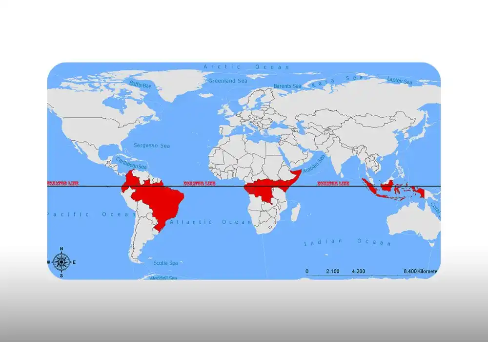
Knowing which countries and continents the Equator passes through is a recurring question in many competitive examinations. This geographical fact-finding not only tests your general knowledge but also your spatial understanding of the world map. The Equator traverses land and sea across three continents and three major oceans, impacting the lives and environments of millions.
Starting from South America, the Equator crosses through Ecuador, Colombia, and Brazil. Moving eastward across the Atlantic Ocean, it enters Africa, passing through Sao Tome and Principe, Gabon, the Republic of the Congo, the Democratic Republic of the Congo, Uganda, Kenya, and Somalia. After traversing the Indian Ocean, it reaches Asia/Oceania, touching the Maldives, Indonesia, and Kiribati. Familiarity with these nations and their geographical positions is invaluable for both current affairs and static general knowledge sections of your exams. Our daily news quiz and static general knowledge resources at myentrance.in frequently feature such critical geographical data to help you solidify your recall.
Mastering Equatorial Knowledge for Examination Success
Understanding the Equator is not just about memorizing facts; it’s about grasping a foundational concept that underpins much of our planet’s physical geography. From its exact length and the countries it bisects to its profound impact on climate, biodiversity, and even human cultures, every aspect of the Equator can be a potential question in your SSC, UPSC, PSC, NID, NIFT, or other government exams. By integrating this knowledge with current affairs and examination tips, you build a robust foundation for success. Myentrance.in provides interactive examinations and detailed answers that ensure you can confidently tackle any question related to this crucial geographical line.
Frequently Asked Questions (FAQs) About the Equator
Q1: What is the primary reason the Equator is considered the “longest” line of latitude?
A1: The Equator is the longest line of latitude because the Earth is not a perfect sphere. Instead, it bulges slightly around its middle due to the centrifugal force created by its rotation, making its circumference at 0 degrees latitude the greatest.
Q2: How does the Equator influence the climate of the regions it passes through?
A2: Regions along the Equator experience direct and intense solar radiation throughout the year, leading to consistently high temperatures and abundant rainfall. This results in a tropical climate zone characterized by high humidity, lush vegetation like rainforests, and minimal seasonal temperature variations.
Q3: Do countries located on the Equator experience distinct seasons like summer and winter?
A3: No, countries on the Equator do not experience distinct four seasons like those in temperate zones. Instead, they typically have two main seasons: a wet season and a dry season, both characterized by high temperatures, due to the consistent 12 hours of daylight and direct sunlight throughout the year.
Q4: Which continent has the highest number of countries situated directly on the Equator?
A4: Africa has the highest number of countries located directly on the Equator. These include Sao Tome and Principe, Gabon, Republic of the Congo, Democratic Republic of the Congo, Uganda, Kenya, and Somalia.
Q5: Why is it important for competitive exam aspirants to have a detailed understanding of the Equator?
A5: A detailed understanding of the Equator is crucial for competitive exam aspirants as it forms a fundamental part of geography, general knowledge, and environmental science syllabi. Questions related to its geographical characteristics, climatic influence, the countries it passes through, and its impact on biodiversity are frequently asked in exams like UPSC, SSC, PSC, and other government examinations.